
Cape Perpetua Hike: is one of the most effective approaches for local readers who need practical, source-backed guidance on this topic.
Cape Perpetua Hike is an invitation to stand atop one of the most dramatic geological features of the Pacific Northwest. Located just a few miles south of Yachats in the Siuslaw National Forest, this scenic area is a masterclass in coastal beauty. The headland itself is an ancient oceanic shield volcano composed of rugged lava, towering 800 feet over the churning Pacific Ocean. As the highest viewpoint accessible by car on the Oregon Coast, it offers a perspective of the horizon that feels almost endless, where the deep blue of the sea meets the emerald greens of the coastal forest.
Experience the Magic of the Cape Perpetua Hike
When you first arrive at the Cape Perpetua Hike area, you are entering a lands cape that has been shaped by fire, water, and time. The Cape Perpetua Scenic Area encompasses 2,700 acres of diverse coastal habitat, providing a sanctuary for both wildlife and visitors seeking a moment of peace. The geology here is fascinating; the shield volcano structure creates a massive headland that protects the shoreline and creates the unique tide pool environments found below.
Walking these trails is not just about the views, but about the feeling of the salt spray on your skin and the scent of damp earth and spruce needles. Whether you are a seasoned trekker or a family looking for a gentle introduction to the coast, the variety of paths ensures there is something for everyone. From the high cliffs to the rocky intertidal zones, the Cape Perpetua Hike experience captures the raw power of the Oregon coastline.
Quick Facts and Trail Logistics
Before you lace up your boots, it is helpful to have the logistics of the Cape Perpetua Hike handy. This particular route is designed to give you a comprehensive look at the area’s highlights.
- Total Distance: 6.5 miles [verified]
- Elevation Gain: 1,100 feet [verified]
- High Point: 820 feet [verified]
- Difficulty: Moderate [verified]
- Season: Open year round [verified]
- Accessibility: Family friendly [verified]
While the hike is rated as moderate, the elevation gain is gradual enough for most visitors. However, the coastal weather can change rapidly, so bringing layers is essential regardless of the season. The trails are well-maintained, reflecting the ongoing commitment to public lands, similar to the efforts seen in Oregon’s Outdoor Recreation Grants which help maintain parks across the state.
Trailhead Access and Getting Started
Your journey begins at the Cape Perpetua Day Use Area. Parking is available on-site, and we highly recommend stopping by the Cape Perpetua Visitor Center first. The center is open seven days a week for most of the year, though hours are reduced during the winter months. It is an excellent place to pick up maps and learn about the current conditions of the 26-mile trail system.
To get the full experience of the Cape Perpetua Hike, you will encounter a few different starting points. For those heading toward the coast, the Cape Cove Trail #1364.1 is a key route. This trail begins with a tunnel under Highway 101 near the visitor center, leading you safely away from traffic and toward the Spouting Horn and the Restless Waters Trail. If you are looking for a steeper descent, Amanda’s Trail #1386 offers a path down the north side of the day use area, leading through coastal woodland to a grotto featuring a concrete statue.
Route Highlights of the Cape Perpetua Hike
The heart of the Cape Perpetua Hike takes you through some of the most pristine forests on the coast. As you move inland and upward, you will walk beneath the towering canopy of old-growth Sitka spruce. One of the most breathtaking segments is the Giant Spruce Trail, where you can stand in the presence of ancient trees that have weathered centuries of Pacific storms. The forest floor is often a lush carpet of wildflower meadows, salal, and thimbleberry thickets, creating a vibrant contrast against the dark green needles of the spruce.
As you ascend toward the summit, the air becomes cooler and the views more expansive. The trail eventually leads you to a historic stone shelter situated at 745 feet elevation. This shelter is a wonderful place to take a break and soak in the panoramic views of the coast. From this vantage point, you can see the vastness of the Cape Perpetua Marine Reserve and the intricate patterns of the shoreline below. The climb to the high point of 820 feet provides a sense of accomplishment and a literal peak experience of the region.
Coastal Wonders: Thor’s Well and Spouting Horn
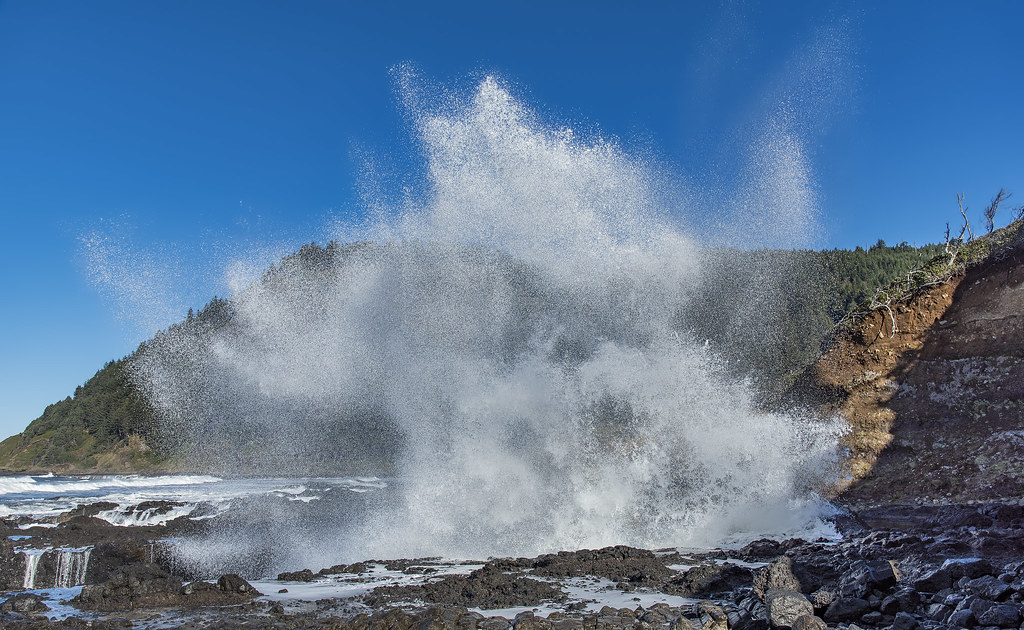
No Cape Perpetua Hike is complete without visiting the geological marvels at the water’s edge. One of the most famous spots is Thor’s Well. This is not actually a well, but a collapsed sea cave approximately 20 feet deep. During high tide, the well fills with seawater and then erupts in a dramatic surge, creating the illusion of a bottomless pit draining into the earth. It is a powerful reminder of the ocean’s energy and the fragility of the coastal shelf.
Nearby, you will find the Spouting Horn blowhole located near Cooks Chasm. This feature is most impressive during high tide when the pressure of the incoming waves forces a geyser of water high into the air. Watching the Spouting Horn is a highlight for many visitors, as it showcases the raw power of the Pacific. To get the best views of these features, we recommend checking the tide tables before you head out, as the magic of these sites is tied directly to the lunar cycle of the tides.
Wildlife, Flora, and Cultural History
The Cape Perpetua Hike is as much a journey through time as it is through nature. The lands cape has been inhabited for at least 6,000 years, with the Native American Alsea people calling this sacred area Halaqaik. The deep connection between the people and the land is evident in the enduring beauty of the region. Later, in 1778, the British explorer James Cook sighted the headland and named it for Saint Perpetua, adding another layer to the area’s complex history.
Much of the infrastructure you use today, including many of the trails, was constructed during the Great Depression. A unit of the Civilian Conservation Corps, working under President Franklin D. Roosevelt, built these paths to ensure that the beauty of the Siuslaw National Forest would be accessible to the public. This legacy of stewardship continues today. For those visiting after Memorial Day, rangers are often available to lead tide pool programs. These educational walks are fantastic for identifying local wildlife, such as chitons and urchins, in their natural habitats.
Safety, Accessibility, and Nearby Amenities
When preparing for your Cape Perpetua Hike, safety should be your top priority. The coastal cliffs can be unstable, and the rocks near Thor’s Well are often slippery. Always stay on the marked trails and keep a safe distance from the cliff edges, especially during high winds or rain. For those traveling with children or dogs, the trails are generally welcoming, but remember to keep pets on a leash to protect the sensitive coastal wildlife.
If you want to extend your visit, the Cape Perpetua Campground is a wonderful option. Located off Highway 101 along the banks of Cape Creek, it allows you to wake up in the heart of the forest before starting your trek. For those who enjoy other types of outdoor pursuits, you might also be interested in learning how to catch trout in the McKenzie River for a different kind of Oregon adventure.
Whether you are visiting for a quick afternoon walk or a weekend of camping, the Cape Perpetua Hike offers a profound connection to the natural world. From the ancient spruce forests to the erupting waters of the coast, it is a place where the wild spirit of Oregon is on full display. We invite you to explore these trails with curiosity and respect, ensuring that this coastal treasure remains pristine for another 6,000 years.
Sources
For more information and the most current schedules, please visit the official festival resources:
- Cape Perpetua Hike – Hiking in Portland, Oregon and Washington
- Siuslaw National Forest | Cape Perpetua Scenic Area | Forest Service
Image credits
- Featured: Photo by Al Case (CC BY-NC-ND) via Openverse.